[FC-04-007] Spaces in Spatial Science
Tags
Author and citation
Zlatanova, S., Yan, J., and Wang, Y. (2024). Spaces in Spatial Science. The Geographic Information Science & Technology Body of Knowledge (2024 Edition), John P. Wilson (Ed.). DOI:10.22224/gistbok/2024.1.16
This entry can also be found at:
DiBiase, D., DeMers, M., Johnson, A., Kemp, K., Luck, A. T., Plewe, B., and Wentz, E. (2006). Space. The Geographic Information Science & Technology Body of Knowledge. Washington, DC: Association of American Geographers.
Explanation
- Notions of Spaces in Different Disciplines
- Space Properties
- Modeling Space Units
- Standards
- Challenges and Opportunities
- Conclusion
1. Notions of Spaces in Different Disciplines
The concept of space has been a subject of debate since the time of ancient philosophers and mathematicians. Traditionally, space has been viewed as an empty expanse—a void—in which other entities exist and events unfold. Over time, mathematical discussions on space have led to the conclusion that space is measurable, uniform, and infinite. It is often regarded as a singular, unified paradigm in which the universe, including planets and constellations, resides. As a result, frameworks like the Euclidean system have been developed to position entities in both absolute and relative terms within a coordinate system. The primary focus of cartographers and surveyors has been to represent objects in absolute space and to map their relationships and interactions in relative space.
This broad concept of space is reflected in most English dictionaries. Despite minor differences, major dictionaries like Oxford, Merriam-Webster, Cambridge, and Collins generally define space as a boundless, three-dimensional, infinite continuum that extends in all directions, within which material objects exist and where all events take place.
However, the everyday use of the word "space" often deviates from this abstract, mathematical definition. In daily life, people refer to space as specific portions of emptiness that hold a particular meaning. For instance, ‘space’ might refer to an area on a desk, within a room, or in a garden. The scale can vary from just a few square meters to hundreds of kilometers. Spaces are often described with qualifiers like "spacious," "lovely," "small," or "cozy," reflecting their emotional or practical significance.
This perception of space as distinct compartments is intuitively applied when modeling space for the purpose of creating digital counterparts of the real world in specific applications. In the virtual world, researchers and developers divide space into discrete portions to study, assign properties, represent relationships, and visualize spatial arrangements. Examples of such properties include weather conditions (e.g., temperature, humidity, wind), accessibility (e.g., accessible, partially accessible, non-accessible), or legal rights (e.g., right of passage, ownership).
Space can acquire the properties of being bounded, limited, or defined as a portion. This should not be viewed as contradictory to the philosophical and mathematical understanding of space but rather as a practical tool for identifying phenomena that are invisible to the human eye yet hold significance and meaning for human beings. To differentiate from the concept of unlimited space, specific portions of space under study have been referred to by various terms, including space unit, space cell, cell, unit, or section, though the term "space" is also commonly used. In line with these distinctions, Princeton's WordNet offers a more nuanced definition that reflects this broader view of spaces.
Since these perceived spaces are human-defined and context-specific, they can vary significantly and even contradict one another depending on the application. This variation may lead to challenges in referencing or addressing spaces consistently.
Figure 1 illustrates disciplines that utilize the notion of space. Several examples of applications which operate on space partitions are further elaborated below.

Navigation and positioning: Navigation involves calculating a route between two points. To facilitate this, navigation algorithms often divide open areas into smaller sections to identify specific locations or to compute paths that guide users to a target destination. Spaces are generally categorized as either indoor or outdoor. Outdoor spaces are typically associated with geographical features related to transportation, such as streets, sidewalks, lanes, and bike paths. Indoor spaces, on the other hand, include rooms, corridors, staircases, and even the empty areas between furniture (Figure 2).

Building Micro-climate and Thermal Comfort: This field relies heavily on subdividing space into distinct building sections, with special attention given to the transition zones between indoor and outdoor environments. These transitions are often informally described as semi-enclosed, semi-indoor, semi-outdoor, or simply as transitional spaces. While not fully enclosed, these areas are thoughtfully designed with features like specialized roofs to provide shade or rain protection, unique walls that offer coziness and privacy, and structures that shield against wind and other weather elements. These design elements aim to enhance comfort while minimizing energy consumption for heating or cooling.
Urban planning: Urban planners place significant emphasis on space enclosures when designing squares, parks, playgrounds, community gardens, and even streets. Their goal is to balance enclosure and openness to harmonize with the surrounding environment while serving the intended purpose of the area. Urban green spaces are another key concept in urban planning, especially in combating urban heat islands (UHI). UHI arises from human-made structures that alter the thermal properties of specific areas. Urban green spaces are often created to mitigate the effects of UHI, with plants playing a critical role in cooling through evapotranspiration. In UHI contexts, spaces are frequently divided into cells defined by non-physical boundaries, determined through sensor data or land cover characteristics such as the presence of vegetation.
Landscape Architecture: The concept of space is extensively utilized by landscape architects, whether within a specific vegetation enclosure, between buildings, or in a combination of both. Landscape architects treat vegetation as positive volumes, akin to architectural elements such as buildings and walls. The "void spaces" are seen as enclosed or semi-enclosed cells, intentionally designed to evoke particular perceptions, enhance aesthetic appeal, ensure security, and create a tranquil atmosphere. Figure 3 illustrates several notions of such spaces.

Interior Design and Planning: Space is a foundational notion for interior design and planning aiming at enhancing the interior space of a building to achieve a healthier and more aesthetically pleasing environment. Interior designers operate with several artefacts such as furnishings, colours, lighting, textures and materials. The concept of positive and negative space is considered for evaluating the balance between spaces filled with ‘stuff’ (e.g., furniture/decoration items) and the ‘empty’ open areas around them. Beyond the construction components (e.g., wall, roof, ceiling, floor, door), furniture and indoor vegetation, some interior features such as lighting, carpets, or room shape can act as boundaries for space planning. The physical 3D objects offer physical boundaries for the spaces while the objects like markers bring in imaginary boundaries.
Spaces in Transportation: In transportation, "road space" is most frequently mentioned. A road space is designed to accommodate traffic and auxiliary areas. The traffic areas include pedestrian pavements and vehicle lanes, while the auxiliary might consist of green spaces such as grass and tree areas. Specific zones are planned to separate people and vehicles, although not all spaces are physically bound, and many are open from above. While transportation spaces are often described in 2D, focusing on the surface area where cars and pedestrians move (Figure 4), 3D concepts are also relevant. For example, tunnels and bridges introduce a 3D aspect to transportation and have been seen as restrictions in 3D.

Intelligent Space: The concept of intelligent spaces is increasingly relevant in urban areas. Intelligent spaces are environments where specific events or phenomena are continuously monitored through a network of sensors. These environments can include neighborhoods, public squares, building entrances, or industrial facilities. Equipped with various sensors—such as environmental sensors, microphones, and cameras—these spaces are used to track processes and movements. For instance, in a factory setting, sensors can oversee and control robotic operations. In this context, an 'intelligent space' may represent a fully artificial partition where communications and functions of interconnected systems are managed autonomously, often without human intervention.

2. Space Properties
As demonstrated above, spaces can be identified according to different properties to serve a range of applications. However, common tendencies can be observed as well.
Classification: Spaces are commonly classified into three categories: indoor, outdoor, and transition (or semi-bounded). Figure 6 illustrates real-world examples of such spaces. Indoor spaces are typically considered completely enclosed and are often associated with protection from weather conditions. In contrast, outdoor spaces are open in the vertical direction (towards the sky) and are therefore exposed to elements like rain, sun, and wind. Although outdoor spaces have boundaries, these are often simply delineations on the ground, such as those seen in road spaces. Transition spaces are the most complex and challenging to define. Their boundaries and characteristics can vary significantly. To describe these spaces, which do not fit neatly into the indoor or outdoor categories, terms like semi-bounded, semi-indoor, and semi-outdoor are used.
As illustrated above and Figure 1, some disciplines utilize all three types of spaces (e.g., navigation and positioning), while others focus exclusively on either indoor spaces (e.g., interior design and planning) or outdoor spaces (e.g., urban planning, landscape architecture, transportation). Transition spaces are primarily concerned with aspects such as building microclimate and thermal comfort. Research on outdoor spaces is particularly extensive, with some types of spaces becoming research topics in their own, such as landscape design, transportation, and safety.
Boundaries: Throughout the disciplines, there are three kinds of boundary that can be used to enclose the spaces: man-made, natural and virtual (fictional). Man-made components are normally used in built environments and can be walls, floors, fences or roofs. The natural components can be vegetation (trees, bushes, and grass), rivers, lakes, hills, rocks, etc. The virtual boundaries are "invisible" but can be identified with the help of sensors measurements (CCTV camera), human perception ("I am in the coffee area"), legal restrictions ("right to pass community area") or computational algorithms such as spaces subdivided by computer algorithm (e.g. for navigation). The boundaries can be combined. For example, man-made and virtual boundaries can delineate spaces in large indoor environments such as airports to indicate "smoking area," "waiting area," or "shopping area."
Both man-made and natural boundary components can be either 2D or 3D and may only partially enclose spaces. In digital representations, these spaces often require virtual boundaries to create a complete enclosure, like spaces to enclose balconies are defined. These digital space units can then be treated like physical objects, with semantic and geometric attributes. Interestingly, the dimension of the boundary—2D (e.g., road delineation) or 3D (e.g., indoor walls)—affects the terminology used to describe the space. Depending on the application, spaces might be referred to differently: for instance, a "shopping area" in a 2D navigation application denotes the walking surface for pedestrians, while "shopping space" in a 3D interior design context refers to the entire visual appearance of the store.
Issues: The variety of space delineations and boundary definitions can lead to contradictions and ambiguities, especially in cross-disciplinary contexts. For example, while ‘indoor’ and ‘outdoor’ are generally well-understood spatial concepts, some definitions of indoor spaces exclude natural enclosed environments like caves and mines. This is because these definitions specifically reference man-made boundaries such as walls, doors, ceilings, and windows, which are not typical of natural settings as mines. Similarly, spaces defined by vegetation are relevant to landscape and urban planning but differ from concepts used in urban heat island (UHI) studies and transportation. Intelligent spaces can further complicate these distinctions, blending indoor, outdoor, and transition elements. Despite this diversity in the use of "space," a common pattern emerges: space is often perceived as a partition (space unit) to which specific properties or functional uses can be assigned.
Advances: Researchers have tried to avoid such misunderstandings by proposing a generic concept for portions of space introducing strict definition for indoor, outdoor, semi-indoor and semi-outdoor and defining the types of boundaries. Indoor is completely bounded by physical (man-made and natural) boundaries. Outdoor is bounded only at the bottom with physical boundary, semi-outdoor is physically bounded at the bottom and at the side. Finally semi-indoor has boundary at the bottom and at the top but can have boundary at the side (to keep the top). The transparency of boundaries has been also given attention, because many spaces can be enclosed with decorative structures and material, which can hardly be considered a boundary.

3. Modelling Space Units
Modeling of partitions of spaces or space units has its challenges and links very closely to the application or phenomena of interest, which in turn affects the representation and geometry.
Representations: Geometric representations applicable for spaces can be categorized into three main groups: Boundary Representation (B-Rep), Constructive Solid Geometry (CSG), and Spatial Occupancy Enumeration. B-Reps, which model objects through their boundaries (points, lines, surfaces, and solids), are widely used. Many GIS, BIM, CAD, and DBMS packages, as well as a variety of virtual environments (such as Google Maps, Google Earth, and Cesium) and game engines (like Unity3D and Unreal Engine), are based on B-Rep models. While B-Reps are well-suited for creating complex shapes, smooth visualizations, and a broad range of 2D spatial operations, they are less effective for performing 3D spatial operations, volume validation, and computation. Additionally, compatibility issues with data types supported by B-Reps can create challenges in data conversion. Figure 7 demonstrates the use of B-reps (ifcSpace) representation of indoor air quality.

Constructive Solid Geometry is a variant of Boundary representation, in which 3D B-reps (cones, spheres, cubes, etc.) are combined in a CSG tree via set of operators such as union, intersection, deletion. CSG is rarely used for modelling real-world phenomena, because the high complexity of the CSG tree complicates the spatial analysis.
In recent years, there has been growing interest in Spatial Occupancy Enumeration, or grid-based methods such as voxels. Voxels, which are the 3D equivalents of pixels in 2D raster models, offer flexibility for both continuous and discrete phenomena. Each voxel can be assigned attributes, data management is intuitive, and various neighborhood operations can be defined. Voxels are widely used for modeling continuous phenomena like geology, maritime environments, and climate, and are increasingly employed for processing point clouds. By using voxel representations, spaces can be modeled with greater detail and appropriate resolution. Grid-based approaches are foundational for simulations and predictions related to temperature distribution, hazard assessment, noise levels, and CO2 concentrations. However, voxel modeling can generate large volumes of data, which necessitates specialized techniques for analysis and visualization.
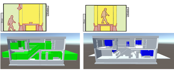
Geometry of space units. In indoor environments, spatial units are typically conceptualized as surfaces and volumes. For example, many navigation or pathfinding methodologies such as IndoorGML, are based on space partitioning. They rely on space delineation according to different user modalities (such as walking, wheeling, crawling, or flying) and tasks (such as navigation or evacuation). These methodologies may use either 2D or 3D spatial dimensions, with navigation networks often leveraging principles from Poincaré duality theory. In such networks, nodes represent individual spatial units, while edges denote the connectivity between them. When 3D approaches are utilized, virtual planes are commonly designed to enclose spaces. These planes function as boundaries, whether they are vertical (e.g., walls) or horizontal (e.g., the top surface of balconies). Figure 8 illustrates the use of voxels to compute available space to accommodate a walking user for evacuation simulation, including spaces above and below furniture.
In the building micro-climate and thermal comfort, the space unit delineation is not that explicit. This can be partly explained by the fact that definitions of these spaces are notion-based or example-based only. However, when simulations are performed to monitor temperature, humidity, noise, or solar intensity, the space units of interest are clearly identified and bounded.
In outdoor-related disciplines such as landscape architecture, urban planning and design, urban heat island studies, and transportation, 2D spaces (areas) are commonly used because outdoor space units are naturally unbounded in the vertical (Z) direction. However, research and development have shown that bounding (vertically) outdoor spaces can also be useful and meaningful. For instance, landscape spaces are often modeled as volumes, with their boundaries defined by surrounding planes. These include the ground plane (terrain), vertical planes (such as bushes and trees), and overhead planes (like canopies) (see Figure 3).
Urban environments can be subdivided into convex and solid voids (volumes) for analysis and classification based on physical measures (such as sky view), safety considerations (like visibility), and street lighting. Some of this space compartmentalization is guided by Gestalt theory, which aims to explain human perception and resulting behavior.
Creating Space units. Traditionally, we measure the boundaries of the visible real-world objects and apply 3D re-construction procedures to obtain their shape. These procedures are guided by the requirements of an application or a discipline to abstraction, resolution, dimensions or accuracy. Space boundaries are identified along physical objects (e.g. room space, landscape space) or virtual boundaries are drawn on the basis of specific measurements like the space for Wi-Fi coverage or according to legal specifications, e.g. ‘apartments space’, which is defined through the centerline of the outer walls.
4. Standards
Standard definitions and representations of space units are crucial for integrating data across various disciplines. Although definitions may differ, consistent standards enable the development of effective mapping tools. Below several well-known standards dealing with space are briefly presented.
Space units are addressed in several international standards, with particular attention given to their geometric representation and the methods for creating these shapes.
The Industry Foundation Classes (IFC) standard, an ISO standard, defines a space as an area or volume that is bounded either "actually or theoretically." IFC spaces are designed to describe specific functions within a building. Typically, a space can be associated with elements such as a building, building storey, room, or any other unit enclosed by construction elements. However, a space unit can also be associated with exterior areas, such as construction sites. These space units are intended to facilitate various computations, including energy use, acoustic analysis, navigation, orientation within the building, and egress simulations, which are critical for diverse interpretations of interior spaces in property and facility management.
The standard IndoorGML is an Open Geospatial Consortium (OGC) standard, which provides a common framework for representation and exchange of indoor spatial information based on 3D spaces. The IndoorGML space cell is bounded by architectural components, where people usually behave in. The space cell has semantics, attributes and relationships. IndoorGML allows to maintain different partitions of space via the Multi-Layer Space Model concept. Space subdivisions can be organised as Topographic Space Layer, Sensor Space Layer, Access Space Layer and so forth.
CityGML is an OGC standard for storage and exchange of virtual 3D city models. CityGML maintains generic semantics and of 3D topographic objects and relationships between them. The last version CityGML 3.0, introduced the concept of space (space units) distinguishing between Physical and Logical (virtual) spaces. Physical spaces are further categorized into occupied and unoccupied spaces. For example, furniture in a room occupies parts of the room’s space. This new space concept is expected to enhance integration between IFC and CityGML, thereby bridging the BIM and GIS domains more effectively.
The Land Administration Domain Model (LADM) is an ISO standard that addresses property descriptions for a wide range of land administration applications. LADM is based on the generic concept of spatial units and administrative entities subject to legal registration. Spatial units may be defined by physical boundaries or by abstract boundaries that delineate legally defined RRRs (rights, responsibilities, or restrictions). These spatial units can represent both indoor (e.g., strata) and outdoor (e.g., parcels) properties within land administration systems. They can be described using two-dimensional (2D) or three-dimensional (3D) geometry, or even textual descriptions, and can be linked to other space standards such as IndoorGML, CityGML, or IFC.
5. Challenges and Opportunities
Clearly, the notion of space is gaining attention. Space is commonly perceived as having three-dimensions and many of the above-mentioned disciplines progressively attempt to advance the digital space representations to 3D. Space is being discretized in varying manners, the definitions, classifications and representations are diverse and discipline specific. Procedures for creating space units are either application-oriented or maybe lacking altogether, particularly in cases involving semi-bounded and outdoor spaces.
On a positive note, many similarities exist across disciplines, suggesting that research on space modeling should evolve to be more cross-disciplinary. This progression could help establish formal definitions and rule-based approaches for defining space units. Cross-disciplinary discussions might lead to a consensus on a generic space concept that could be included in standards and serve as a foundation for discipline-specific applications. There is a need for formal frameworks that include rules and thresholds to guide the creation, use, and analysis of space units across various fields. By doing so, parameters defined in one field could be adapted or translated for use in others.
Presently, the approaches to model indoor space are much more refined and elaborated compared to the notions for outdoor spaces. However, the push for sustainable urban developments or zero carbon buildings demands integrated indoor-outdoor modelling approaches. This highlights the need for research to develop frameworks that bridge the gap between indoor and outdoor space modelling. Such integration would simplify information management and create a platform for seamless indoor-outdoor applications. Similar approaches can be applied in other disciplines where human activities or environmental phenomena extend beyond the confines of a building.
In this context, new approaches to representing space and physical entities must be explored to enable a unified yet consistent representation. 3D grid-based models are particularly promising for integrating information from 3D models and sensor measurements, facilitating 3D spatial analysis, simulations, and predictions. Investigating hybrid B-rep and voxel modeling and management techniques could lead to the development of flexible Digital Twins that support comprehensive space-based environmental analysis.
6. Conclusion
The space is being discretized in varying manners according to the application, yet many similarities exist between the investigated disciplines. This is a strong indication that research on space modelling should evolve to cross-disciplinary, which could help establish formal definitions and rule-based approaches for defining space and would support artificial intelligence approaches. Cross-discipline discussions on definition might lead to a consensus on a generic space concept that can be included in standards and used as basis for discipline-specific purposes.
References
- Booth, N.K. (1989). Basic Elements of Landscape Architectural Design. Long Grove, IL: Waveland Press, Inc.
- Thill, J.C. (2011). Is Spatial Really That Special? A Tale of Spaces. In: Popovich, V., Claramunt, C., Devogele, T., Schrenk, M., Korolenko, K. (eds) Information Fusion and Geographic Information Systems. Lecture Notes in Geoinformation and Cartography(), vol 5. Springer, Berlin, Heidelberg.
- Wang, W., Chang, Q., Li, Q., Shi, Z., and Chen, W. (2016). Indoor-Outdoor Detection Using a Smart Phone Sensor. Sensors 16, 1563.
- Zlatanova, S., Yan, J., Wang, Y., Diakité, A., Isikdag, U., Sithole, G., and Barton, J. (2020). Spaces in Spatial Science and Urban Applications—State of the Art Review. ISPRS International Journal of Geo-Information. 9(1):58.
Learning outcomes
-
299 - Define the four basic dimensions or shapes used to describe spatial objects (i.e., points, lines, regions, volumes)
Define the four basic dimensions or shapes used to describe spatial objects (i.e., points, lines, regions, volumes)
-
721 - Develop methods for representing non-cartesian models of space in GIS
Develop methods for representing non-cartesian models of space in GIS
-
738 - Differentiate between absolute and relative descriptions of location
Differentiate between absolute and relative descriptions of location
-
741 - Differentiate between common-sense, Cartesian/metric, relational, relativistic, phenomenological, social constructivist, and other theories of the nature of space
Differentiate between common-sense, Cartesian/metric, relational, relativistic, phenomenological, social constructivist, and other theories of the nature of space
-
809 - Discuss the advantages and disadvantages of the use of cartesian/metric space as a basis for GIS and related technologies
Discuss the advantages and disadvantages of the use of cartesian/metric space as a basis for GIS and related technologies
-
824 - Discuss the contributions that different perspectives on the nature of space bring to an understanding of geographic phenomenon
Discuss the contributions that different perspectives on the nature of space bring to an understanding of geographic phenomenon
-
1414 - Justify the discrepancies between the nature of locations in the real world and representations thereof (e.g., towns as points)
Justify the discrepancies between the nature of locations in the real world and representations thereof (e.g., towns as points)
-
1566 - Select appropriate spatial metaphors and models of phenomena to be represented in GIS
Select appropriate spatial metaphors and models of phenomena to be represented in GIS
Related topics
Additional resources
Booth, N.K. (1989). Basic Elements of Landscape Architectural Design; Waveland Press: Long Grove, IL, USA.
Thill, J-C. (2011). Is Spatial Really That Special? A Tale of Spaces, Chapter 1 in: Popovich, V., et al. (eds.), Information Fusion and Geographic Information Systems: Towards the Digital Ocean, Lecture Notes in Geoinformation and Cartography 5, Springer-Verlag Berlin Heidelberg.
Wang, W., Chang, Q., Li, Q., Shi, Z., and Chen, W. (2016). Indoor-Outdoor detection using a smart phone sensor. Sensors, 16, 1563. https://doi.org/10.3390/s16101563.
Zlatanova, S., Yan, J., Wang, Y., Diakité, A., Isikdag, U., Sithole, G., and Barton, J. (2020). Spaces in Spatial Science and Urban Applications—State of the Art Review. ISPRS International Journal of Geo-Information, 9(1): 58. https://doi.org/10.3390/ijgi9010058