[KE-02-018] Regional Multi-Jurisdictional GIS Coordination & Collaboration
This article discusses the regional multi-jurisdictional GIS concept for collaborative organization and service delivery of geospatial data, technology, resources, and services. At the local and regional level, many local government agencies overlap – they share geography. Cities and towns exist within counties, and multiple cities and counties may exist within a regional planning agency. Cities, counties, tribal governments, utilities, and transit agencies may serve the same geographic region. Citizens expect local government agencies to be prudent stewards of financial resources. A collaborative regional, multi-jurisdictional approach to GIS organization and operation provides many opportunities for more cost- effective geospatial services. This article introduces the concept of regional multi-jurisdictional GIS, reviews early history, and outlines the benefits, structures, and challenges involved. Three case studies put the concepts discussed into context.
Author & citation
Babinski, G., Croswell, P., and Holdstock, D. (2025). Regional Multi-Jurisdictional GIS Coordination and Collaboration. The Geographic Information Science and Technology Body of Knowledge (Issue 2, 2025 Edition), John P. Wilson (Ed.). DOI: 10.22224/gistbok/2025.2.21
Explanation
- Introduction to Regional Multi-Jurisdictional GIS
- Early Development of Regional Multi-Jurisdictional GIS
- Societal and Organizational Benefits of Regional Multi-Jurisdictional GIS
- Types of Regional Multi-Jurisdictional GIS
- Case Study 1: King County, Washington's 30-Year Journey to Regional GIS
- Case Study 2: Louisville/Jefferson County Information Consortium (LOJIC)
- Case Study 3: Regional District Central Kootenay (RDCK): Modernizing Regional GIS Governance
- Summary
1. Introduction to Regional Mult-Jurisdictional GIS
This article discusses the regional multi-jurisdictional concept for collaborative GIS organization and service delivery of geospatial data, technology, resources, and services. The focus is on local government agencies that utilize GIS to support the delivery of municipal services. At the local and regional level, many local government agencies overlap – they share geography. Cities and towns exist within counties, and multiple cities and counties may exist within a regional planning agency. Cities, counties, tribal governments, utilities, and transit agencies may serve the same geographic region. Citizens expect local government agencies to be prudent stewards of financial resources. A collaborative regional approach to GIS organization and operation provides many opportunities for more cost- effective geospatial services. GIS operations are usually funded by individual agencies that have their own government services business focus. The connection between funding for GIS and expected utilization of GIS usually leads to a siloed approach to GIS design and operation. There are well documented examples of collaborative GIS at the state or provincial level (Chesser et.al 2019).
A special case is the European Union Inspire Directive, a multi-national program which mandates the development and maintenance of spatial data for all EU member states and from the national level down to the local government level (European Parliament 2007). The Inspire Directive in part states:
The early development of GIS (1960-1975) focused at the national level. Key initiatives included Roger Tomlinson and the Canadian Geographic Information System, Edgar Horwood at the University of Washington and the focus on US Census data, and David Bickmore and the Experimental Cartographic Unit at the Royal College of Art focused on the UK Ordinance Survey (Chrisman 2020).
This article, instead, focuses on the first-tier subdivisions within state and provincial governments in the US and Canada, and the potential benefit of GIS collaboration with second-tier entities that share geography or geographic adjacency (Babinski 2020). During the period of pioneering implementation of GIS (1975-1995) at the regional and local level, high costs for GIS hardware, software, and data led some agencies to consider regional collaborative GIS to share costs and risk.
A collaborative regional approach allowed agencies to share the cost and risk of building a GIS and putting it into operation. For agencies that share geography, like a county and the municipalities within the county, development of a shared database and applications allowed costs to be shared and GIS to be implemented more quickly. However, most agencies focused on their own independent GIS development and opportunities were lost for data cost sharing and collaborative operations. Institutional and personal barriers were erected that made even considering regional GIS a challenge. As opposed to the handful of regional GIS consortium that exist, the vast majority of the more than 3000 US counties have no regional GIS. However, some agencies are again considering regional GIS collaboration to realize the now proven benefits that sharing spatial data and other resources can provide.
2. Early Development of Regional Multi-Jurisdictional GIS
Lane County, Oregon is considered to be the oldest regional multi-jurisdictional GIS, called the Regional Land Information Database (RLID). In the early 1960s, Eugene County, the City of Eugene, four other cities, a neighboring county, and various other private and government entities agreed to form the Lane County Cooperative Data Center (LC4) LC4 received the first IBM 360/Model 30 mainframe computer in 1965 (Weber et.al. 1972).
RLID was an outgrowth of LC4, enabled by the regional cooperative organizational structure and governance (CPA) put in place by the partner agencies. By the mid-1970s the CPA facilitated the first regional GIS at Lane County and Lane County Council of Government partner agencies.
Notable early regional multi-jurisdictional GIS entities include (Croswell 2015):
- Lane Council of Governments RLID, Eugene, Oregon (~1975)
- San Diego Geographic Information Source (SanGIS), San Diego, California (~1985)
- Knoxville Knox County Knoxville Utilities Board (KUB) GIS (KGIS), Knoxville, Tennessee (~1986)
- Indianapolis/Marion County Geographic Infrastructure System (IMAGIS), Indianapolis, Indiana (~1987)
- Johnson County (Kansas) AIMS (Automated Information Mapping System), Olathe, Kansas (~1987)
- Pulaski Area Geographic Information System (PAgis), Little Rock, Arkansas (~1989)
- Metro GIS (Twin Cities, MN), St Paul, MN (~1997)
3. Societal and Organizational Benefits of Regional Multi-Jurisdictional GIS
Benefits of regional multi-jurisdictional GIS are inherent for government agencies that share geography. The Inspire Directive summarizes benefits for harmonized data across all European Union nations, including interoperability of spatial data sets and services, the identification of standard defined data themes, and a networked infrastructure to enable spatial data sharing. Inspire also established data and metadata standards, data-sharing standards, principles of public access to data, and appropriate confidentiality of personal data. Inspire specifies 34 specific spatial data themes and the development of the Inspire GeoPortal for access (European Parliament 2007). At a regional GIS level, within five years of its inception, Inspire enabled Kielce, a medium sized city in Poland, to develop and put into use a sophisticated municipal GIS, integrated at multiple regional levels, for city planning, citizen engagement, and municipal operations (Ciupa et al. 2012).
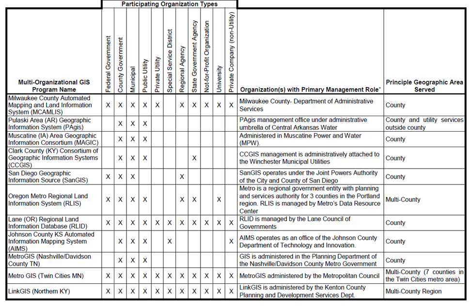
Within the United States and Canada, a comprehensive survey of 40 regional multi-jurisdictional GIS entities identified, classified, and ranked a number of recuring benefit types (Table 1).
Table 1. Ranked Benefits from Regional Multi-Organizational GIS Programs. Source: Croswell 2015, used with permission.
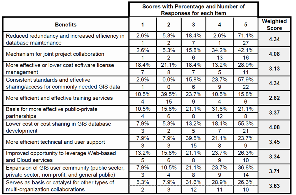
Although regional multi-jurisdictional GIS is most often initiated at the county or regional agency level, important benefits are realized by small jurisdictions, which in many cases would not have the financial or staff resources to access GIS data and tools on their own (Croswell 2015).
An important benefit for regional multi-jurisdictional GIS is as an information and data sharing forum. Such a forum can also discuss the specific potential benefits outlined in Figure 1, to consider pursuing them with the regional context. Forums can be formal or informal and include government agencies, academic entities, non-profits, etc. Forum purposes can include (Jonson et.al. 2001):
- A network to share information and educate members
- A mechanism to share data and applications
- A means to resolve technical and institutional data sharing challenges
- A forum to endorse standards and devise practices to facilitate regional GIS collaboration
- A means of aggregating regional data
Another way to think about the benefits of regional multi-jurisdictional GIS within a county/municipal environment is to focus on the typical responsibilities of counties and cities. Although variations exist, often in the US these are typical government responsibilities:
- Counties: Assessments, Elections
- Cities: Public works, utilities, planning, permitting
- Both counties and cities: Policing, roads, parks
Cities are stakeholders in county activities related to property assessment and elections. The cadastral mapping associated with the county assessor’s office is often the foundation for municipal GIS. Counties and cities often collaborate on utilities and comprehensive planning. And citizens expect good integrated policing, roads, and parks without regard to jurisdictional boundaries. This focus on county and municipal responsibilities and overlap provides a guide to where the greatest benefits from regional GIS could be derived. At a societal level, citizens, voters, taxpayers, and businesses all expect that government agencies will be prudent in their use of financial resources and always seek the most cost-effective ways to deliver government services (Babinski 2020).
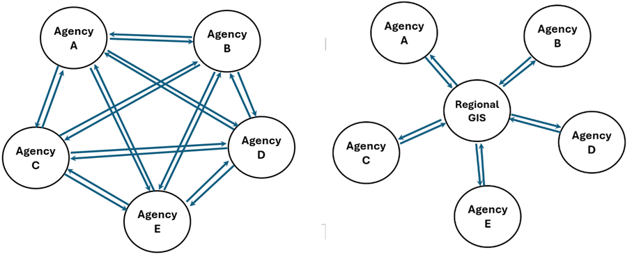
A common theme in regional multi-jurisdictional GIS is the concept of replacing a many-to-many environment for interacting with other agencies with a many-to-one structure where a central collaborative resource makes agency GIS interactions and collaboration more efficient and effective (Figure 1).
4. Types of Regional Multi-Jurisdictional GIS
Regional multi-jurisdictional GIS entities can be categorized several ways (Croswell 2015).
The most common lead agency types include:
- County government
- Municipal government
- Regional agency
- Public utility
Most common participating agency types include:
- Municipal government
- County government
- Public utility
- Regional agency
- State government agency
- Private (non-utility) company
- University
- Non-profit
- Private utility
- Non-utility service district
- Federal government agency
Table 2. Typical regional multi-jurisdictional GIS entity lead/participating agencies. Source: Croswell 2015, used with permission.
For a regional multi-jurisdictional GIS to be successful, two important factors are the type of mandate or legal vehicle for the entity, along with the governance structure.
Types of mandates include (Croswell 2015):
- Legislation, regulation, or ordinance (21%)
- Executive order (5%)
- Formal agreement or MOU (44%)
- Data sharing license (34%)
- Written policy (7%)
- Subscription of formal membership (21%)
- Other mandate (13%)
- No formal mandate (42%)
Governance is an important factor for any regional multi-jurisdictional GIS entity to operate effectively. Types of governance bodies include (Croswell 2015):
- Policy or governing body (63%)
- Advisory body (31%)
- Steering Committee (26%)
- Technical Committee (47%)
- Working groups (34%)
- User Group (55%)
- Other group or body (26%)
Note that percentages for types of mandates and governance bodies each total more than 100% because in some cases there was more than one type reported by individual agency.
Most regional multi-jurisdictional GIS entities are based on jurisdictions with overlapping geography, as with counties or regional agencies and the cities and other jurisdictions located within. However, regional GIS entities can be successful when comprised of neighboring jurisdictions only. An example is the eCityGov Alliance, made up of a dozen suburban cities east of Seattle, Washington, and located in two counties. The eCityGov Alliance was created via an inter-local agreement and governed by a board comprised of representatives from each member agency. The eCityGov Alliance was created partly to resist domination by Seattle and King County and to maintain suburban control and viewpoint in its programs and operations. In addition to GIS services and aerial imagery coordination, the Alliance also provides other types of shared systems, like permitting and purchasing systems (eCityGov Alliance 2018).
5. Case Study 1: King County, Washington's 30-year Journey to Regional GIS
For regional multi-jurisdictional GIS entities not established when GIS was first developed, it is challenging later to transition multiple independent GIS operations into a collaborative regional structure.
King County, Washington is a case study where regional GIS has been pursued for more than 30 years. Institutional challenges and impediments have repeatedly slowed implementation of regional GIS within the county.
Planning for GIS in King County and Seattle began in parallel in the early 1980s. An original 1991 King County GIS development plan included close collaboration with the City of Seattle and a $22 million price. This however was rejected by the King County Council in favor of their own $6.8 million proposal (King County Council Central Staff 1993). This reduced cost proposal still included the development as a regional GIS (Figure 2).
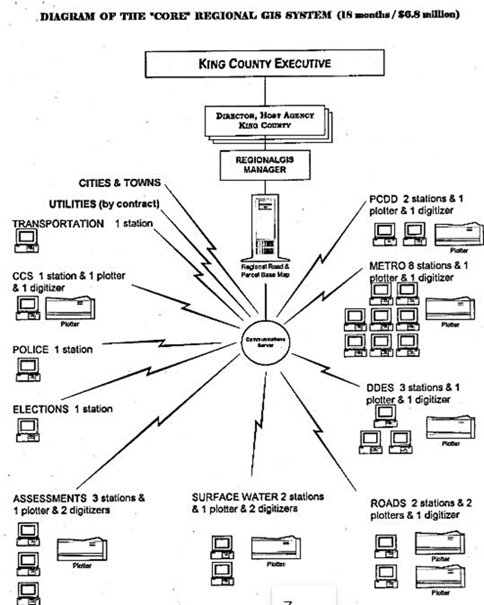
However, because of the reduced budget, it was not feasible to include any of the components of a regional GIS in the capital project, although a GIS data sharing agreement with Seattle was signed. By 1997 King County GIS transitioned from a capital project to regular operations and maintenance.
For the next 25 years King County continued to reexplore a regional GIS. In 1999 the current King County Executive (who had been a Council Member at the time of the 1993 report) convened a meeting of local government IT leaders, members of the local business community, and King County IT and GIS leadership to discuss restarting a regional GIS initiative. However, nothing came of this effort because of lack of funding and no concrete plan to establish a regional GIS.
In 2001 the County reorganized GIS into an internal service fund, operating under the name King County GIS Center, and authorized by County Code to provide its services to outside entities. Approximately 30% of the King County GIS Center staff were assigned to work for outside agencies on a cost-reimbursable basis (King County GIS Center 2002). In effect, the funding basis for the King County GIS Center forced it to focus on providing regional GIS services, but without a regional charter or governance. Types of services provided on a regional basis included:
- A GIS training program complete with a 16 workstation training facility.
- GIS data sharing and database compilation with all 39 municipalities, plus tribes, regional agencies and neighboring counties.
- GIS development and project work for regional agencies.
- Regional coordination and direct contract services for the decennial LUCA (Local Update of Census Addresses) mandate.
- Regional arial imagery acquisition and sharing.
- Temporary staffing for small GIS operations when vacancies occurred.
The success of the King County GIS regional client services program depended on an entrepreneurial approach that the King County GIS funding model required (Eichelberger 2006). However, funding challenges for GIS within King County, especially following the 2008 international financial crisis, led again to a search for ways to reduce costs without impacting programs. A 2016 paper by an outside consultant analyzed the potential for regional GIS and proposed a framework for achieving this goal (Johansen 2016). The key building blocks of this plan included:
- Develop a detailed business case that is compelling, has broad support, and is actionable
- Develop a framework that embodies initiative goals, collaboration, and decision making
- Conduct a pilot project, or proof-of-concept demonstration, to validate both business case and framework
This and a related internal analysis of the imperative to pursue regional GIS led to a 2017 budget proposal for a consultant to help plan and develop a new King County Regional GIS. With strong support from the County CIO, Budget Office, County Executive, and County Council, the proposal was approved in the 2017 Budget. However, in early 2017 when the RFP was being developed, the County Chief Technology Officer refused to allow the RFP to go forward. Once again, institutional impediments blocked the full development of regional GIS.
However, approval was given for King County GIS to convene a steering committee of regional GIS managers to develop a regional GIS plan themselves. Rebranding themselves the Sound to Summit Regional GIS, from 2016 through 2021 the steering committee crafted a regional GIS implementation plan that was adopted by consensus in December 2021 (Babinski 2021). As of 2025, the regional GIS steering committee has transitioned into a governance structure to guide the implementation of the Sound to Summit Regional GIS.
LOJIC is a partnership of organizations in the greater Louisville area (Jefferson County KY and surrounding counties) providing geographic data, maps and GIS services to public sector agencies, utility organizations, non-profit groups, the private sector, and the general public. The LOJIC Policy Board, including senior members of the Partner organizations: Louisville Metro Government, Louisville/Jefferson County MSD, Louisville Water Company, and the Jefferson County Property Value Administrator (PVA), provides oversight, direction, and financial support.
A memorandum of agreement (MOA) ratified on an annual basis describes the operating rules and commitments of Partner organizations. LOJIC operations and services are managed and provided by a LOJIC Director and staff. Support and guidance are provided by a LOJIC Steering Committee which includes GIS professionals from partner organizations. LOJIC users include employees of the four Partner organizations, staff of external organizations which have license agreements for LOJIC support, and a wide range of private sector, not-for-profit organizations, external government agencies, and the general public who access LOJIC data and Web-based GIS services and applications. (Croswell et.al. 2015).
7. Case Study 3: Regional District Central Kootenay (RDCK): Modernizing Regional GIS Governance
In British Columbia, Canada, a regional district is an administrative subdivision of the province that consists of a geographic region with specific boundaries and governmental authority. Regional districts serve to provide municipal services as the local government in areas not incorporated into a municipality, and also for certain shared concerns or interests between unincorporated areas and municipalities, such as regional planning and the GIS data and applications essential for effective multi-agency planning.
The Regional District of Central Kootenay (RDCK) is in south-central British Columbia, with its administrative offices in Nelson, BC. An example of a regional GIS service provided by RDCK is the RDCK Regional Roundtable Wildfire Resiliency Tool, which compiles wildfire management datasets for accessibility on different end-user agency GIS platforms (Regional District Central Kootenay 2025).
In 2025 RDCK undertook a comprehensive five-year GIS Strategic Plan to modernize geospatial services, address governance and staffing gaps, improve data quality, and enhance regional collaboration with its municipal partners. The initiative aimed to position GIS as an enterprise asset supporting decision-making, emergency management, infrastructure planning, and public engagement across the region. RDCK utilized a consultant to conduct a detailed Needs Assessment, including stakeholder interviews, online surveys, data inventory, and SWOT analysis, to evaluate GIS usage and identify service gaps. The needs assessment was benchmarked against the Six Pillars of GIS Sustainability: assessing governance, data management, workflows, technology, training, and organizational culture. This analysis informed the design of a regional GIS governance framework, with defined roles, responsibilities, and decision-making processes, and the development of a phased implementation roadmap.
The assessment revealed strong departmental reliance on GIS for emergency response and planning but highlighted critical gaps: absence of a formal governance structure, inconsistent municipal adoption, outdated datasets, limited system integration, and insufficient training. The proposed hybrid-regional governance model includes a GIS Steering Committee, municipal and departmental user groups, formal service level agreements, and standardized data stewardship. It also calls for expanded staffing, enhanced mobile/offline capabilities, and improved public-facing applications.
Implementing the strategic plan and governance framework will transform RDCK’s GIS into a coordinated, region-wide service, enabling consistent data standards, stronger municipal collaboration, and more efficient resource use. The regional model offers a scalable blueprint for inter-jurisdictional GIS governance, enhancing transparency, operational efficiency, and the value of geospatial technology in local government service delivery.
Regional multi-jurisdictional GIS is an organizational option that provides many benefits for agencies that implement it. Successful examples of regional GIS have been in operation since the very beginning of municipal GIS implementation. It is possible to create a multi-national GIS environment that brings the benefits of regional GIS to local entities, if the political will is present.
Regions that want to implement regional GIS today face obstacles, but case studies and surveys of successful regional GIS point the way for the future. It is imperative for regions with existing collaborative GIS to develop an effective governance structure and a comprehensive strategic plan and renew their strategic plan on a periodic basis to ensure that it remains relevant to address stakeholders’ evolving needs.
References
- Babinski, G. (2019). Good GIS Practices for Best-Run County Governments. In Valcik, Nick and Dean, Denis, Geospatial Information System use in Public Organizations: How and Why GIS should be used by the Public Sector. Routledge Press.
- Babinski, G. (2021). Sound to Summit Regional GIS: Future Regional GIS Recommendations Report. Seattle: King County GIS Center, December 31, 2021.
- Chesser, J., Rogers, K., Ross, D., and Smith, C. (2019). Multi-organizational GIS Coordination. The Geographic Information Science & Technology Body of Knowledge (4th Quarter 2019 Edition), John P. Wilson (ed.).
- Chrisman, N. R. (2020). Academic Developments of GIS&T in English-speaking Countries: a Partial History. The Geographic Information Science & Technology Body of Knowledge (1st Quarter 2020 Edition), John P. Wilson (ed.).
- Ciupa, S., Dzwonkowska, K., and Kisiel, J. (2012) Using a Geographical Information System as a Platform to Integrate Local Strategies in Kielce, Poland. The GIS Professional. Issue 247, January/February 2012.
- Croswell, P. L. (2022). The GIS Management Handbook, 3rd Edition. Frankfort, Kentucky: Kessy Dewitt Publications.
- Croswell, P., Taylor, S., and Taylor, S. (2015). Recommendations on LOJIG Governance, Funding, and Operational Improvements: Innovative GIS Best Practices for the Louisville/Jefferson County Information Consortium. Croswell-Schulte IT Consultants, Frankfort, KY.
- eCityGov Alliance (2018). Amended and Restated Interlocal Agreement Establishing eCityGov Alliance. eCityGov Alliance, Bellevue, Washington. Accessed December 20, 2025.
- Eichelberger, P. (2006). Entrepreneurial Approaches to Countywide GIS Services. Proceedings of the 2006 URISA Annual Conference, Vancouver, BC
- European Parliament, Council of the European Union. (2007). Directive 2007/2/EC of the European Parliament and of the Council of 14 March 2007 establishing an Infrastructure for Spatial Information in the European Community (INSPIRE).
- Johansen, K. (2016). Reassessing the Puget Sound Regional GIS Option. Privately published paper. Karl Johansen, 2016.
- Johnson, R., Nedovic-Budic, Z. & Covert, K. (2001). Lessons from Practice: A Guidebook for Organizing and Sustaining Geodata Collaboratives. Reston, Virginia: Geodata Alliance.
- King County Council Central Staff (1993, May 12). Work Notes: Regional GIS Concept.
- King County GIS Center. (2002). King County GIS Production Operations and Maintenance Plan. King County GIS Center.
- Regional District Central Kootenay (RDCK). (2025). RDCK Quarterly Report, Q1 2025. RDCK Corporate Administration, Nelson, BC.
- Weber, P.R., Rickert, J. E., and Norman, D. R. (1972) Regional Cooperative Data Processing in Local Government. URISA Annual Conference Proceedings. San Francisco.